Synopsis:
Happy New Year!
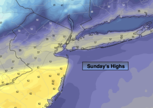
The low responsible for our wet New Years will move offshore this morning. Showers will come to an end. Clouds will remain. As the front continues to pull offshore Sunday readings will begin to tumble during the mid to late afternoon.
January will show its true colors on Monday as a cold blast arrives. The computer models have pushed a strengthening area of low pressure closer to our coast. What this means is that the potential for some snow is now in the forecast for areas South and East of the City for a part of Monday. Areas North and West as of this writing look to be snow-free. Please stay tuned to JMW for the very latest on this fluid situation.
High pressure over the region on Tuesday will deliver abundant sunshine and seasonal readings.
Temperatures will pop on Wednesday to several degrees above the average high of 40º.
Thursday will be seasonal as another front moves through with a mix of sun and clouds.
Stay tuned..
Sunday:
Scattered showers morning showers, otherwise remaining cloudy. Mild. Highs in the mid 50s. Temperatures falling later in the day. West to Northwest winds at 5-10mph.
Tonight:
Mostly cloudy and much colder. Lows in the 20s throughout. North wind at 8-15mph.
Monday:
Mostly cloudy, windy and colder. Potential of some snow South and East of the City during the day. Highs in the lower to mid 30s.
Tuesday:
Sunny. Seasonal. Highs around 40º.
Wednesday:
Party sunny. Mild. Highs around 50º.
Thursday:
Party sunny. Seasonal. Highs in the lower 40s.