Synopsis:
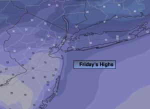
We’ll be in between systems through early tonight. The atmosphere is quite moist and stagnate. This will result in plenty of clouds with limited sun. Readings on Friday will be at least ten degrees above the average high of around 40º.
At the stroke of midnight New Year’s Eve readings will be in the 40s in our region with dry conditions. Soon after though scattered showers will be developing.
2022 will start off wet with low pressure heading our way from the Southwest on Saturday. Scattered showers are likely. There looks to be a bit of dry time before a steadier rain develops during the afternoon. It’ll be balmy with readings feeling more like Spring than January 1st.
A second low over the Southeast will ride up and along a stationary front offshore of our region on Sunday. Scattered showers are in the forecast with mild conditions continuing. As the front pulls offshore Sunday readings will begin to tumble during the mid to late afternoon.
January will show its true colors on Monday as a cold blast arrives. Temperatures will be only near freezing for daytime highs despite the sunshine. The wind will add a bite.
High pressure over the region on Tuesday will deliver abundant sunshine and seasonal readings.
Still no snow in the forecast snow lovers.
Stay tuned..
Friday (New Year’s Eve):
Mostly cloudy. Mild. Highs in the lower 50s. South winds at 5mph.
Tonight:
Mostly cloudy. Scattered showers developing late. Lows in the lower to mid 40s in the City, near 40º inland. These readings are warmer than then the average high for the day. Southwest winds less than 5mph.
Saturday (New Year’s Day):
Scattered showers. There will be dry times. Steadier rain developing during the afternoon. Balmy. Highs in the mid to upper 50s.
Sunday:
Mostly cloudy with scattered showers. Mild. Highs in the mid 50s. Temperatures falling later in the day.
Monday:
Mostly sunny, windy and colder. Highs only around freezing.
Tuesday:
Sunny. Seasonal. Highs around 40º.