Synopsis:
Weak areas of low pressure will move through the tri-state area through Thursday. There will be minor bouts of mainly scattered showers through this time.
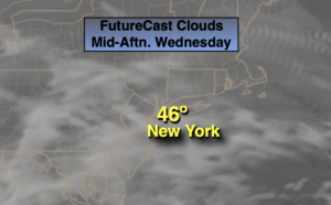
Morning showers will taper off this morning, but the clouds will hang tough. Readings will be several degrees above the average high of 42º .
Another round of showers will work into the region tonight.
Thursday will remain mainly cloudy. There’s a slight chance of showers, as another weak system rapidly moves through.
Friday (New Year’s Eve) will be the best day of the bunch with abundant sunshine and readings still above average.
2022 will start off dry, but low pressure heading our way fro the Southwest has the potential to throw rain into the picture by afternoon. It will be balmy with readings feeling more like Spring than January 1st.
A second low over the Southeast will ride up and along a stationary front offshore of our region on Sunday. Scattered showers are in the forecast with mild conditions continuing.
Stay tuned..
Wednesday:
Scattered morning showers, otherwise, remaining cloudy. Highs in the mid 40s. Northeast winds at 5mph.
Tonight:
Scattered showers. Lows in the lower 40s in the City, the 30s inland. North to Northeast winds at less than 5mph.
Thursday:
Mostly cloudy. Spotty showers are possible. Mild. Highs around 50º.
Friday (New Year’s Eve):
Mostly sunny. Mild. Highs in the lower 50s.
Saturday (New Year’s Day):
Increasing clouds. Balmy. Rain likely by afternoon. Highs near 60º.
Sunday:
Mostly cloudy with scattered showers. Mild. Highs in the mid 50s.