Synopsis:
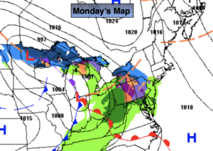
Weak low pressure over the Great Lakes will weaken as it approaches the region today. Any sunshine East will give way to thickening clouds. Rain, snow and sleet showers are possible during the afternoon. A light coating of snow, sleet or ice is possible North & West later today. Slick spots are likely on untreated surfaces.
Scattered showers or a bit of sleet well North will taper off late.
A mixed sky is on tap for Tuesday. Clouds will increase during the afternoon. Temperatures will still be above average as weak high pressure ridges in from the Great Lakes.
Wednesday will feature low pressure moving in. Showers are possible.
We’ll get another chance of showers again on Thursday as another weak system rapidly moves through.
Friday will be the best day of the week with abundant sunshine and readings still above average.
Stay tuned..
Monday:
Thickening clouds with a chance of afternoon rain, sleet and snow showers. Cold. Highs in the 30s to around 40º along the immediate coast. Winds becoming Southeast at 5mph.
Tonight:
Rain showers, a bit of sleet well North tapering off after midnight. Lows in the mid 30s in the City, the 20s inland. There will be slick spots on untreated surfaces and where readings are below freezing. Southeast to Northwest winds at 5mph.
Tuesday:
Sun to clouds. Mild. Highs in the upper 40s.
Wednesday:
Showers possible. Mild. Highs in the upper 40s.
Thursday:
Showers possible. Mild. Highs in the upper 40s.
Friday:
Mostly sunny. Mild. Highs in the mid to upper 40s.