Synopsis:
Weak areas of low pressure will move through the tri-state area through Thursday. There will be minor bouts of mainly scattered showers through this time.
Scattered showers or a bit of sleet well North will taper off late tonight.
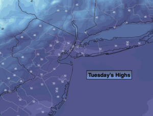
A mixed sky is on tap for Tuesday. Temperatures will still be above average as weak high pressure ridges in from the Great Lakes. The average high is 42º.
Wednesday will feature low pressure moving in. Showers are possible.
We’ll get another chance of showers again on Thursday as another weak system rapidly moves through.
Friday (New Year’s Eve) will be the best day of the bunch with abundant sunshine and readings still above average.
2022 will start off dry, but low pressure heading our way has the potential to throw rain into the picture by afternoon.
Stay tuned..
Tonight:
Scattered rain showers, a bit of sleet well North, tapering off late. Lows in the mid 30s in the City, the 20s inland. There will be slick spots on untreated surfaces and where readings are below freezing. East winds at 5mph.
Tuesday:
Clouds and sun. Mild. Highs around 50º. Northwest winds at 5-10mph.
Wednesday:
Morning showers possible. Highs in the mid 40s.
Thursday:
Morning showers possible. Mild. Highs around 50º.
Friday (New Year’s Eve):
Mostly sunny. Mild. Highs in the lower 50s.
Saturday (New Year’s Day):
Increasing clouds. Mild. Rain possible by afternoon. Highs in the lower 50s.