Synopsis:
Canadian high pressure will dominate Thursday. Skies will be bright, but it’ll be chilly.
A weak disturbance will move rapidly into our region tonight. Scattered snow showers are possible for an hour or two.
A mix of sun and clouds is expected on Friday-Christmas Eve as high pressure settles over the Southeastern US.
It looks like we’ll have to wait another year for a white Christmas. The day will be mild with a chance of showers.
Sunday will be the better half of the weekend with abundant sun with just above average temperatures.
Low pressure moving in from the West will result in the possibility of light rain mixed with snow on Monday. This doesn’t look like a big deal at this time.
Stay tuned..
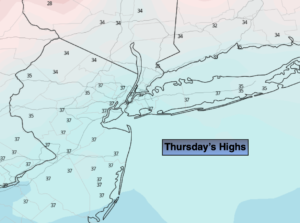
Thursday:
Sunny, colder. Highs in the upper 30s. Northwest winds at 8-12mph.
Tonight:
Mostly cloudy. Scattered snow showers possible late. Lows around freezing along the coast, the 20s inland. West to South winds at 5mph.
Christmas Eve:
Sunny. Highs in the mid 40s.
Christmas Day:
Mostly cloudy with scattered showers. Highs in the mid to upper 40s.
Sunday:
Mostly sunny. Highs in the mid 40s.
Monday:
Chance of light rain with areas of light wet snow. Highs in the upper 3os.