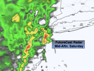
Synopsis:
Early morning sun on Saturday will give way to more clouds during the day. Scattered showers are possible during the afternoon as upper level energy swings through. This will make for an unstable atmosphere-isolated thunderstorms are also possible. It will become breezy to windy along the coast. Readings will be seasonal.
Sunday will be a typical November day under a mix of sun and clouds with readings several degrees below average a flow prevails out of Canada.
On Monday, weak low pressure will develop near the region. More clouds than sun is expected with scattered showers possible early in the morning.
Tuesday will be bright and chilly as high pressure moves in from the Northwest.
Temperatures will rebound on Wednesday with a Southwesterly wind developing around high pressure to our South.
Stay tuned.
Saturday:
Early sun to mostly cloudy skies. Scattered showers during the afternoon with isolated thunderstorms. Highs in the mid to upper 5os. Southeast to West winds increasing to 15-25mph with gusts to 45 along the coast.
Tonight:
Clear. Much colder. Lows in the upper 30s in the City, the 20s and 30s inland. West winds at 15-30mph early then diminishing.
Sunday:
Partly sunny. Cooler. Highs around 50º.
Monday:
Clouds and sun. Scattered showers possible. Highs in the lower 50s.
Tuesday:
Mostly sunny. Chilly. Highs in the upper 40s.
Wednesday:
Sunny. Milder. Highs in the upper 50s.