Synopsis:
It will become unsettled early this week. The first system will move in Monday. A warm front will swing to our North during the early morning. It now looks like the majority of the day will be dry with a mix of clouds and sun. Spotty showers are possible later in the day. It’ll be warm.
A steadier rain and heavier rain threat is increasing for Tuesday and Tuesday night as the models are now developing a storm just offshore the NJ and Long Island coast. This has the potential to be a Nor’easter. The exact track and set up of the rain bands will determine who will receive the heaviest rain. A few inches of rain is quite possible in spots. Flash flooding and coastal flooding may become an issue. The highest winds will be along the coast with gusts up to 50mph possible.
The storm will pull farther offshore Wednesday. Morning clouds should give way to some afternoon sun. The winds will continue to be busy.
Thursday we’ll dry out as the sun dominates as high pressure moves in .
The next system will begin to move in from the South on Friday. Early sun will give way to the potential of late day showers.
Keep it here for a no hype-no nonsense forecast.
Stay tuned.
Tonight:
Mostly cloudy. Lows in the mid to upper 50s in the City, the 40s & 50s inland. South winds at 5mph.
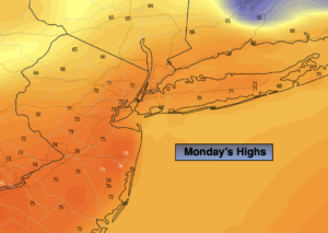
Monday:
Clouds and some sun. Spotty late day showers are possible. Warm. Highs in the lower 70s.
Tuesday:
Rain likely. Becoming Windy. Much cooler. Highs in the lower to mid 50s.
Wednesday:
Clouds giving way to afternoon sun. Windy. Highs in the lower 60s.
Thursday:
Partly sunny. Highs in the lower 60s.
Friday:
Partly sunny early. Thickening clouds with afternoon showers possible. Highs around 60º.