Synopsis:
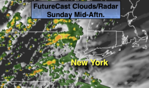
August’s debut will feature a mix of sun and clouds during the morning. Scattered showers will develop toward midday to the South and West. The showers will overspread much of the area during the afternoon. It won’t be a washout. It will be unseasonably cool. Temperatures will be around ten degrees below the average high of 85º. This wet weather is due to a disturbance moving in from the West.
On and off showers are likely tonight as the low pushes offshore.
The beginning to mid portion of the upcoming week will be bright and comfortably warm as weak high pressure dominates.
The next chance of showers comes Thursday. A Southerly flow and offshore frontal boundary will combine to bring in the showers.
Keep it here for a no nonsense, no hype forecast.
Today:
Morning sun and clouds giving way to scattered showers from late morning South and West to the afternoon hours in the NYC vicinity and to the East. It won’t be rainy all the time and there will be dry times. It’ll be unseasonably cool for August. Highs in the mid 70s. Southeast winds at 5-10mph.
Tonight:
Scattered showers. Lows in the mid 60s in urban areas, the upper 50s inland. South wind becoming Northwest at 5mph.
Monday:
Mostly sunny. Highs around 80º.
Tuesday:
Mostly sunny. Highs around 80º.
Wednesday:
Partly sunny. Highs in the lower 80s.
Thursday:
Increasing clouds. Showers possible. Highs around 80º.