Synopsis:
The 4th of July holiday weekend will be a 50/50 split. Saturday will feature mainly cloudy skies. On and off showers are in the forecast. The unsettled conditions are due to an an upper level low and surface low pressure in the vicinity. This low pressure system has unseasonably cool air associated with it. Temperatures will remain in the mid 60s for highs! Not looking like a beach day nor feeling like Summer.
Scattered showers will continue tonight. Not all areas will get wet.
Sunday, July 4th will be the better half of the weekend. More sunshine and milder readings are anticipated. An isolated shower or storm is possible. Readings will still be around ten degrees below the average high of the mid 80s.
Typical July conditions will return for the beginning of next week as high pressure builds over the Southeastern portion of the nation. The result will be increasing heat and humidity under mostly sunny skies. A spot storm is possible by Wednesday afternoon.
Stay tuned.
Keep it here for a no nonsense, no hype forecast.
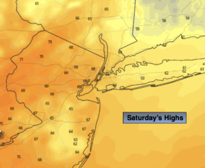
Saturday:
Mostly cloudy with scattered showers. Unseasonably cool. Highs in the mid to upper 60s. North wind at 8-15mph.
Tonight:
Scattered showers. Very cool. Lows in the 50s throughout. North winds at 5mph.
4th of July:
Partly sunny. An isolated shower or storm. Highs in the mid to upper 70s.
Monday:
Mostly sunny. Much warmer. Highs in the lower to mid 80s.
Tuesday:
Hazy, hot and humid. Highs in the lower 90s.
Wednesday:
Hazy, hot and humid. Spotty PM Storm. Highs in the lower 90s.