Synopsis:
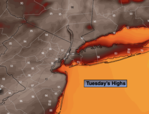
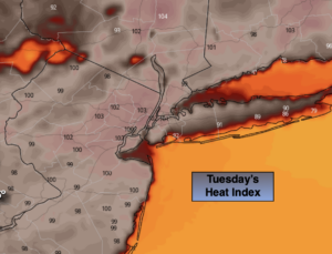
A Bermuda high will dominate much of the East coast through at least Wednesday-the last day of June. This will result in the continuation of the heatwave. Mainly sunny skies, high temperatures and high humidity is expected. The combination of the readings in the 90s and high humidity will result in a heat index, the way it actually feels, between 98º-105º. Record highs maybe in jeopardy the next couple of days.
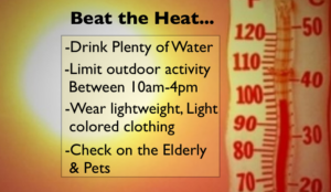
Please listen to your body as heat of this magnitude is taxing to our body. If you feel weak or disorientated take a break. Drink plenty of fluids and get into a cooler environment. Coastal communities will be better off with cooler readings with the ocean influence.
Overnight lows will only be in the 70s to near 80º in urban areas.
A cool front will approach on Thursday will some relief from the high heat. Cooling scattered afternoon thunderstorms will be moving through.
By Friday, the front will be over the region with scattered showers and storms and more seasonal readings (the lower to mid 80s).
On Saturday, a more refreshing airmass will be upon us. A few scattered showers can’t be ruled out with upper level energy swinging through. A mix of sun and clouds is expected. Readings will be a few degrees below average. Many will smiling!
Stay tuned.
Keep it here for a no nonsense, no hype forecast.
Tuesday:
3 H’s. Highs in the mid to upper 90s, cooler at the coast. Heat index: 98º-105º.
Tonight:
Partly cloudy with patchy fog. Very warm. Lows around 80º in urban areas, the 70s elsewhere. Southwest winds at 5mph.
Wednesday:
3 H’s. Spot PM storm. Highs in the mid to upper 90s. Cooler at the coast. Heat index: 98º-105º.
Thursday:
Hazy, not as hot. Still humid. Scattered PM storms. Highs in the mid 80s.
Friday:
Mostly cloudy with scattered showers and storms. Highs around 80º.
Saturday:
Sun and clouds. Spotty showers. Cooler. Highs in the upper 70s.