
Synopsis:
High pressure over the Western Atlantic this the weekend will pump up the heat and humidity as we transition from Spring to Summer. Spring’s finale on Saturday will feature hazy, hot and humid conditions. A spotty thunderstorm is possible in the building humidity by later in the afternoon.
Scattered showers and storm are possible tonight with a weak disturbance moving through.
Father’s Day Sunday, which by the way is the first day of Summer, will be every bit like Summer. Sunny, very warm and humid conditions are expected. The Summer Solstice occurs at 11:32PM EDT.
Monday will be steamy under hazy sunshine. The humidity will peak as a tropical connection set up from the Bahamas.
On Tuesday, a cool front will approach. Scattered showers and storms are likely. It won’t be as hot, but the humidity will be high.
Relief will arrive on Wednesday as high pressure works in. It’ll be cooler and much less humid. Readings will be just below the average high of the lower 80s.
Stay tuned.
Keep it here for a no nonsense, no hype forecast.
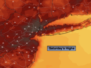
Saturday:
Hazy sun, hot and humid. Spotty late day storms. The majority of the time the weather will cooperate. Highs around 90º. West winds at 5-10mph.
Tonight:
Partly cloudy with scattered showers and storms. Muggy. Lows around 70º in urban areas, the 60s inland. West winds less than 5mph.
Father’s Day:
Sunny, very warm and humid. Highs in the upper 80s.
Monday:
Steamy with hazy sun. Highs in the lower 90s.
Tuesday:
Warm and humid. Scattered showers and storms. Highs in the mid 80s.
Wednesday:
Sunny. Much cooler and less humid. Highs in the upper 70s.