Synopsis:
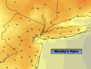
Relief has arrived behind a cold front. It’ll be dramatically cooler today with readings only in the 60s. A far cry from our 90º heat of Sunday. It will be refreshing.
Tuesday will be a comfortable day with readings closer to the average high of the lower 70s under a mix of clouds and sun as high pressure moves off the coast
By Wednesday, readings once again will feel like a day out of July as a southwesterly flow around a Bermuda high takes hold. The warm weather will stick into Thursday under a mix of sun and clouds.
Cooler Readings are expected for the end of the week with a wind off the Atlantic. It now looks like an area of low pressure may give us some much needed rain by Friday afternoon. Some start the rain dance-PLEASE!
Keep it here for a no nonsense, no hype forecast.
Monday:
Becoming mostly sunny. Much cooler. Highs only in the upper 60s. East to Southeast winds at 10-15mph.
Tonight:
Partly cloudy and cool. Lows in the mid 50s in urban areas, the upper 4os inland. South winds at 5mph.
Tuesday:
More clouds than sun. Highs in the lower 70s.
Wednesday:
Partly sunny and very warm. Highs in the upper 80s to around 90º.
Thursday:
Mostly sunny. Warm. Highs in the mid 80s.
Friday:
Mostly cloudy with the chance of afternoon rain. Much cooler. Highs in the upper 60s.