Synopsis:
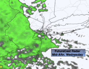
Weak low pressure will move up the coast today. The morning hours should remain dry. Rain will work in from West to East during the afternoon (map above) and become steady by late day. A period of heavy rain is possible for Central and Southern areas later in the day and into the evening. It’ll be much cooler with wind off the cold Atlantic. Readings will be near the average high of 52º.
Rain will end early tonight and skies will remain mostly cloudy. It’ll be mild with all readings in the 40s.
We’ll be back to the sunshine and warm temperatures for Thursday as high pressure regains control.
By Friday, a weak cool front will approach. Spotty showers are likely during the morning. The sun will return and readings will pop into the lower to mid 70s by afternoon.
The better half of the weekend will be Saturday. Bright and mild conditions are expected. Low pressure develop over the area on Sunday with periods of rain.
Keep it here for a no nonsense, no hype forecast.
Today:
Cloudy. Rain developing during the afternoon. A period of heavier rain is likely later in the day. Much cooler. Highs in the lower 50s. East winds at 5-10mph.
Tonight:
Rain. Heavy early in spots. Becoming mostly cloudy after midnight. Lows in the 40s throughout. Light winds.
Thursday:
Sun and clouds. Much warmer. Highs in the upper 60s to lower 70s. .
Friday:
Partly sunny. Warm. A spot shower is possible during the morning. Highs in the lower to mid 70s.
Saturday:
Mostly sunny. Mild. Highs in the lower 60s.
Sunday:
Mostly cloudy. A period of rain is likely. Highs in the mid 50s.