Synopsis:
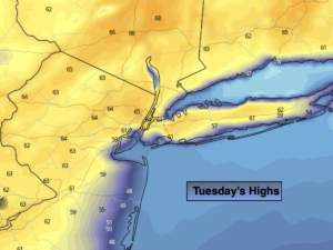
High pressure will dominate our weather today as it moves off the Northeast coast. It’ll be bright and mild with readings in the lower to mid 60s; cooler readings at the coast (map above depicts this nicely).
Clear skies early tonight will give way to increasing clouds. All readings will be well above freezing.
Weak low pressure will move up the coast on Wednesday. Clouds will dominate and a period of rain is likely. The rain will be scattered during the morning hours, then become steadier during the afternoon. It’ll be much cooler with wind off the cold Atlantic. Readings will be several degrees below the average high of 52º.
We’ll be back to the sunshine and warm temperatures for Thursday as high pressure regains control. By Friday, a cool front will approach. A spot shower is possible at this time. It’l be May-like with readings around 70º.
The weekend will start off bright and mild.
Keep it here for a no nonsense, no hype forecast.
Today:
Sunny. Highs in the lower to mid 60s. Much cooler at the coast. Northeast to East winds at 5-10mph.
Tonight:
Increasing clouds. Lows in the lower 40s in the City, the upper 30s inland. Light winds.
Wednesday:
Cloudy with a period of rain. Much cooler. Highs in the mid 40s.
Thursday:
Sun and clouds. Much warmer. Highs in the upper 60s to lower 70s. .
Friday:
Partly sunny. Warm. A spot shower is possible. Highs in the lower 70s.
Saturday:
Mostly sunny. Mild. Highs in the lower 60s.