Synopsis:
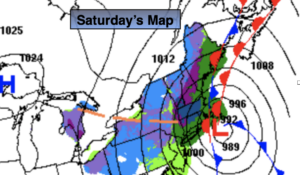
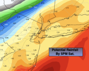
A storm will move from off the NJ coast this morning to Cape Cod by late afternoon and intensify quite rapidly. Rain, some of it heavy this morning with taper off by late morning or midday over Western areas. There will be a sharp cutoff from heavy rainfall totals to lighter amounts North and West (2nd map above). One to two inches of coastal rainfall is expected with much lighter amounts as you go North and West. Some wet snow may mix in especially to the North and East of the City during the afternoon. The sun may shine West of the City sometime during the afternoon, with rain continuing East of the City until sunset. It will be windy with gusts between 30-45mph out of the North and Northwest behind the departing strengthening storm.
Clear and cold conditions are expected tonight. Winds will diminish some but still add a bite.
Sunday will be the better half of the weekend as the sun returns. Readings will be below average both days.
Tranquil but chilly conditions are expected early next week. Readings will be several degrees below the average high of the upper 40s.
Stay Tuned.
Keep it here for a no nonsense, no hype forecast.
Today:
Rain. Rain tapering off midday West of the City. The rain will continue to the East through the afternoon. A bit of wet snow may mix in over Northern and Eastern areas later in the morning and afternoon. Some afternoon sun is possible West of the City. Windy. High in the upper 30s to lower 40s. North to Northwest winds at 15-25mph with gusts to 45mph at the coast.
Tonight:
Clear, breezy and cold. Lows around freezing in the City, the 20s inland. Northwest winds at 15-25mph.
Sunday:
Mostly sunny, breezy and chilly. High in the lower 40s.
Monday:
Mostly sunny. High in the lower 40s.
Tuesday
Mostly sunny. High in the lower 40s.
Wednesday:
Mostly sunny. High in the mid 40s.