Synopsis:
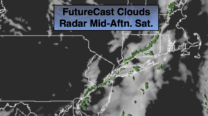
This morning will start off cloudy with areas of fog. A cool front will move through during the afternoon (an isolated shower is possible). Increasing sunshine is expected during the afternoon. It will continue to be Spring-like with readings well above the average high of the lower 60s.
A major shock will occur tonight as temperatures will be almost twenty degrees colder than last night. High pressure over Northern New England will bring down the chill.
It’ll feel like a different season on Sunday as readings will be well below average. Sun will give way to increasing clouds. Scattered showers are possible later in the day especially from the City and to the South as moisture rides North from a weak disturbance.
The clouds will continue to run the show early next week as cool front inches its way toward the East coast. Monday and Tuesday will be mainly cloudy and seasonal. A spot shower is possible Monday. A better chance of scattered showers will be with us Tuesday as the front approaches. The sun will return Wednesday as the system moves offshore.
Stay Tuned.
Keep it here for a no nonsense, no hype forecast.
Today:
Morning clouds and fog to some afternoon sun. Mild. Highs in near 70º. Southwest to Northwest winds at 5-10mph.
Tonight:
Clear and much colder. Lows in the mid 40s in the City, the 30s inland. Northwest to North winds at 8-12mph.
Sunday:
Morning sun will give way to afternoon clouds. Scattered late afternoon showers are possible, especially South of the City. Much cooler. Highs in the lower to mid 50s.
Monday:
Mostly cloudy. A spot shower is possible. Highs in the lower 60s.
Tuesday:
Mostly cloudy. Scattered showers possible. Highs around 60º.
Wednesday:
Clouds to sun. Highs in the upper 50s.