Synopsis:
Today will be warm under a mix of sun and clouds. The humidity will be lower.
A disturbance will work in tonight with scattered showers and storms.
Friday will feature a mix of sun and clouds as weak stationary front will be draped over the area. This feature will spark scattered showers and storms during the afternoon.
A cool front will approach Saturday it will be warm ahead of the front. Scattered showers are possible under a partly cloudy sky but most of the day will be dry.
Sunday will be more comfortable with plenty of sunshine as high pressure influences our area from the Northwest.
The beginning of the next week looks delightful.
Stay Tuned.
Keep it here for a no nonsense, no hype forecast.
Today:
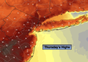
Partly sunny, warm and less humid. Highs in the mid 80s. West to South winds at 5-10mph.
Tonight:
Mostly cloudy with scattered showers and thunderstorms. Warm. Lows near 70º in the City, the 60s inland. South winds at 5mph.
Friday:
More clouds than sun. Scattered afternoon showers and storms. Highs in the lower 80s.
Saturday:
Partly sunny. Spotty showers. Highs in the mid 80s.
Sunday:
Mostly sunny. Much lower humidity. Highs in the upper 70s.
Monday:
Sunny. Comfortable. Highs in the upper 70s.