
Synopsis:
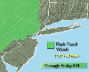
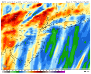
Today will cloudy and windy as a developing low along a front to the West moves our way. Spotty showers are possible, but the majority of the day will be dry. The steadiest rain looks to hold off until evening. A period of heavy rain is likely tonight as the system moves over the region. One to three inches of rain is possible and a Flood Watch has been issued for areas North and West of the City.
Friday-May 1st will be mostly cloudy (maybe a peek or two of sun if we’re lucky) as the storm moves into Eastern New England. The morning should be dry. Scattered showers and thunderstorms are possible during the afternoon as upper level energy with the departing storm moves through.
Our first weekend of May will be delightful. Saturday will be mainly sunny with highs a few degrees above the average high of 66º. Partly sunny skies are expected for Sunday with similar warm readings. Definitely a weekend to get outdoors!
Stay Tuned.
Keep it here for a no nonsense, no hype forecast.
Today:
Clouds and windy. Widely scattered showers are possible. Steady rain will hold off until the evening. Highs in the lower 60s. Southeast winds at 15-30mph with gusts to 45mph at the coast.
Tonight:
Rain, heavy at times. Lows in the lower to mid 50s throughout. Southeast winds at 15-25mph with higher gusts. Winds will diminish after midnight.
Friday:
Mostly cloudy. The morning will be dry. Spotty showers and thunderstorms are likely during the afternoon. Highs in the mid to upper 60s.
Saturday:
Mostly sunny. Warm. Highs around 70º.
Sunday:
Partly sunny. Highs in the lower 70s.
Monday:
Morning showers, otherwise becoming partly sunny. Highs in the upper 60s.