

Synopsis:.
Today will be mostly sunny and several degrees below the average of 52º. Clouds will roll in later in the day as high pressure moves offshore.
Low pressure will move to the Northeast out of the Central Appalachian states tonight. Rain is likely to develop from Southwest to Northeast early tonight.
The models develop an upper level low with the surface low pressure. This feature will enhance the rainfall. Moderate to heavy rain is possible for a time later tonight into Sunday morning. The storm will move South of Long Island and toward Cape Cod. There is a low potential for a bit of freezing rain and or sleet and wet snow well North and West but this doesn’t look like a major concern at this time. Expected rainfall of up to 2″ is possible. The NAM model (2nd map above) and European model (3rd map above) both show the hefty rainfall amounts.
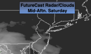
The rain will taper between midday and mid afternoon Sunday. If were lucky we may get to see the sunset!
The beginning of next week looks tranquil with plenty of sunshine and tolerable temperatures.
Getaway Wednesday will be mild with a mix of clouds and sun. Spot showers are possible during the afternoon.
The forecast for Thanksgiving at this time looks dry and cool.
Stay Tuned.
Keep it here for a no hype, no nonsense forecast.
Today:
Mostly sunny. Late day clouds. Highs in the mid to upper 40s. West to Southwest winds at 5-10mph.
Tonight:
Rain developing later this evening. The rain could be heavy at times late. There maybe pockets of freezing rain well North and West. Lows around 40º in the City, the 30s inland. South to Northeast winds at 5-10mph.
Sunday:
Rain, possibly heavy early. A mix of freezing rain, sleet and or wet snow is possible in spots well North and West. The rain will taper off midday to early afternoon. Skies may brighten later in the afternoon. Highs in the mid 40s.
Monday:
Mostly sunny. Highs around 50º.
Tuesday:
Partly sunny. Highs in the mid 50s.
Wednesday (Getaway Day):
Partly sunny, breezy and mild. Spot afternoon showers are possible. Highs in the mid to upper 50s.