Synopsis:.
Low pressure will strengthen over Chesapeake Bay tonight. Rain will develop from Southwest to Northeast between 9PM and Midnight. The storm will hug our coast later tonight and Sunday. The models develop an upper level low with the surface low pressure. This feature will enhance the rainfall. Moderate to heavy rain is possible for a time later tonight into Sunday morning. The storm will move over Long Island and toward Cape Cod. There is a low potential for a bit of freezing rain and or sleet and wet snow well North and West as colder air filters down from the upper atmosphere. This doesn’t look like a major concern at this time.
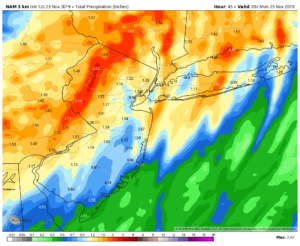
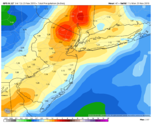
Expected rainfall of 1″ to 3″ is possible. The NAM model (1st map above) and GFS model (2nd map above) both show the hefty rainfall amounts. The jackpot zone looks to be just North and West of the City.
The rain will taper between midday and mid afternoon Sunday, again IF there is enough cold air aloft a few flakes may fly North and West.
The beginning of the upcoming shortened workweek looks tranquil with plenty of sunshine and tolerable temperatures.
Getaway Wednesday will be very mild with a mix of clouds and sun. Spot showers are possible during the afternoon as a cold front approaches.
Thanksgiving will be much cooler and windy under a mix of sun and clouds. A strong Northwest flow will be with us do to a powerful Canadian maritime storm and strong high pressure over Central Canada.
Stay Tuned.
Keep it here for a no hype, no nonsense forecast.
Tonight:
Rain developing later this evening. The rain could be heavy at times late. There maybe pockets of freezing rain well North and West. Lows around 40º in the City, the 30s inland. South to Northeast winds at 5-10mph.
Sunday:
Rain, possibly heavy early. A mix of freezing rain, sleet and or wet snow is possible in spots well North and West. The rain will taper off midday to mid afternoon. Skies may brighten later in the afternoon. Highs in the mid 40s in the City, near 50º over Long Island and the upper 30s North and West.
Monday:
Mostly sunny. Highs around 50º.
Tuesday:
Partly sunny. Highs in the mid 50s.
Wednesday (Getaway Day):
Partly sunny, breezy and mild. Spot afternoon showers are possible. Highs in the upper 50s.
Thanksgiving:
Partly sunny, windy and chilly. Highs in the mid 40s.