Synopsis:.
Early morning clouds today will give way to sunshine. It will be more tolerable as low pressure pulls away to the Northeast. A bit of wet snow did fall well North early this morning up the Hudson Valley (a coating occurred in the higher elevations).
A bright day is expected for Wednesday and Thursday as high pressure moves in from the West. Temperatures will remain below normal then rise to near seasonal averages by Thursday.
A cold front will approach Friday. Ahead of it it’ll be mild under a mix of sun and clouds. An isolated shower is possible later in the day.
Saturday will start off with sun but clouds will roll in for the second half of the day. Low pressure will move to the Northeast out of the Central Appalachian states. Showers are possible later in the day Saturday or on Saturday night.
Stay Tuned.
Keep it here for a no hype, no nonsense forecast.
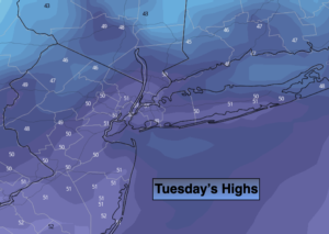
Today:
Morning clouds, otherwise skies will be partly sunny. Highs around 50º. West to Northwest winds at 5-10mph.
Tonight:
Mostly cloudy. Lows in the 30s throughout. Northwest winds at 5-10mph.
Wednesday:
Mostly sunny. Highs in the upper 40s.
Thursday:
Mostly sunny. Highs in the lower 50s.
Friday:
Sun and clouds, milder. Spotty PM showers. Highs in the upper 50s.
Saturday:
Sun and clouds. Much cooler with a chance of afternoon showers. Highs in the upper 40s.