Synopsis:.
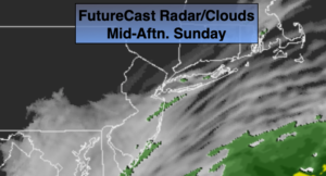
Any sunshine on Sunday will fade behind increasing clouds as a storm’s cloud shield works North from off the North Carolina coast. Coastal showers are possible today, otherwise most regions will remain dry. Readings will be well below the average high of 54º. Windy conditions are expected along the coast. Minor to moderate coastal flooding may occur during times of high tide through Monday. Beach erosion is also possible. The high pressure over Maine and a coastal storm off the Southeastern seaboard will create a strong Northeast flow along the coast and rough seas.
The storm off the East coast will graze our area tonight and Monday with the potential of on and off rain or showers.
Early morning clouds Tuesday will give way to sunshine. A bright day is expected for Wednesday and Thursday as high pressure moves in from the West. Temperatures will remain below normal then rise to near seasonal averages by Thursday.
Stay Tuned.
Keep it here for a no hype, no nonsense forecast.
Today:
Early sun giving way to mostly cloudy skies. Chilly. Afternoon coastal showers are possible. Breezy. Highs in the lower 40s. Northeast winds at 10-20mph with higher gusts at the coast.
Tonight:
Areas of showers or drizzle. A few of the colder spots well inland maybe just cold enough for some freezing drizzle. Lows in the mid to upper 30s in the City, near 30º well inland. Northeast winds increasing at 10-20mph with higher gusts at the coast.
Monday:
On and off showers. Highs in the lower to mid 40s.
Tuesday:
Morning clouds to partly sunny skies. Highs around 50º.
Wednesday:
Mostly sunny. Highs around 50º.
Thursday:
Mostly sunny. Highs in the lower 50s.