Synopsis:.
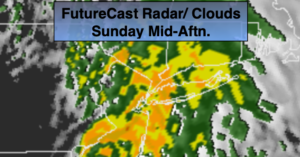
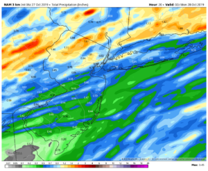
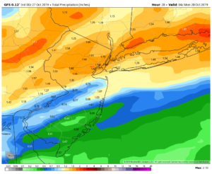
A low over the Great Lakes will weaken and a secondary storm will form over the tri-state area today. Abundant moisture will be available and rain will become steady by mid morning. A period of heavy rain is likely through early to mid afternoon as the storm intensifies and moves to the North and East. One to two inches of rain is likely. The NAM and GFS model (maps above) are similar in their potential rainfall amounts with the heaviest totals expected for the Northern 1/2 of the area. There will be areas of street and highway flooding in poor drainage areas. It’ll be mild with a East to Southerly wind. Winds may gusts above 25-35mph for a time during the morning hours. The rain will taper off from West to East during the mid-afternoon hours.
The beginning of week will be bright and mild as high pressure builds over the region.
On Tuesday on onshore flow will cause clouds to prevail. It’s be cooler with spotty drizzle possible.
Wednesday will be bright and mild ahead of an approaching system from the West.
Halloween at this time looks to be mostly cloudy with scattered showers as a front moves in from the West.
Stay Tuned.
Keep it here for a no nonsense, no hype forecast.
Today:
Periods of rain, locally heavy through early to mid-afternoon. Windy for a time and mild. Highs in the mid 60s near 70º to the South. East winds at 15-25mph with gusts to 35mph through midday. Winds will turn to the West later in the day at 10-15mph.
Tonight:
Becoming mostly clear. Lows in the mid 50s in the City, the 40s inland. Northwest winds at 5-10mph.
Monday:
Mostly sunny. Highs in the mid 60s.
Tuesday:
Mostly cloudy, cooler with spotty drizzle possible. Highs around 60º.
Wednesday:
Partly sunny, mild. Highs in the mid 60s.
Halloween:
Mostly cloudy. Chance of showers. Highs in the mid 60s.