Synopsis:.
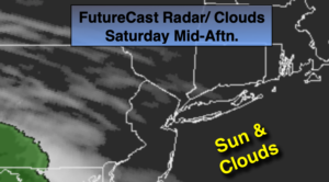
The weekend will be a 50/50 split. Today will be cool with a second area of high pressure to the North. Once again, the sun and clouds will battle it out, but the clouds will be the winner for the second half of today. On Sunday, a low will develop to our South and West and move toward the region. Periods of rain is likely.
The beginning of week will be bright and mild.
On Tuesday on onshore flow will cause clouds to prevail. It’s be cooler with spotty drizzle possible.
Wednesday will be bright and mild ahead of an approaching system from the West.
Keep it here for a no nonsense, no hype forecast.
Stay Tuned.
Saturday:
Sun & clouds, cooler. Highs around 60º. North to East winds at 5-10mph.
Tonight:
Mostly cloudy. Chance of late scattered showers. Lows in the lower 50s in the City, the 40s inland. East winds at 5-10mph with higher gusts toward daybreak.
Sunday:
Periods of rain, locally heavy through midday. Highs in the mid 60s.
Monday:
Mostly sunny. Highs in the mid 60s.
Tuesday:
Mostly cloudy, cooler with spotty drizzle possible. Highs around 60º.
Wednesday:
Partly sunny, mild. Highs in the mid 60s.