Synopsis:
At this time it looks like we’ll take 2 out of 3 days for the Labor Day Holiday Weekend. High pressure will build in from the North today and tomorrow. Sun and clouds are expected with near seasonal temperatures (around 80º). On Labor Day Monday a cool front will approach. There is a chance of scattered showers. It doesn’t look like a washout.
Warmer readings are anticipated as we head back to work and school midweek.
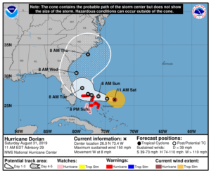
Hurricane Dorian is now moving West in the Atlantic East of the Bahamas. Dorian is a major hurricane- category 4 status with sustained winds, as of this writing of 150mph. The hurricane will slow down as a strong ridge of high pressure over the Western Atlantic and steers the hurricane West. Upper level winds will become weak. Dorian may stall for a time over the Northern Bahamas (2nd map above). Where Dorian makes landfall is not known at this time. The million dollar question where does it go after that? Does it turn North before, along or after reaching the FL coast? If it turns North before reaching the coast much of FL will be spared it’s catastrophic effects. If it turns North just a bit later it will not be a good scenario. At this time the trend is for the storm to remain just offshore of Florida. Do not concentrate on the exact track but look at the cone of possibility. Hope for the best, prepare for the worst. The entire Southeastern coast has the potential to feel the affects of Dorian later this upcoming week.
Stay Tuned.
Keep it here for a no nonsense, no hype forecast.
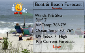
Saturday:
Sun and clouds. Highs lower 80s. Northeast winds at 5-10mph.
Tonight:
Partly cloudy. Lows in the mid to upper 60s in the City, the 50s inland. Northeast winds at 5mph.
Sunday:
Sun & clouds. Highs in the upper 70s.
Labor Day:
More clouds than sun. Scattered showers possible. Highs around 80º.
Tuesday:
Partly sunny and warm. Highs in the lower to mid 80s.
Wednesday:
Partly sunny, warm and more humid. Late showers are possible. Highs in the mid 80s.