Synopsis:
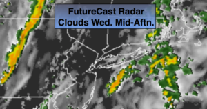
Clouds will dominate today. The humidity will be much higher than recent days with a Southerly flow. The combination a front approaching from the West and some moisture getting in the mix from Tropical Depression Erin well off the coast will result in scattered showers and possible thunderstorms just about anytime, but much of the time will be dry. The best threat will be in the afternoon and evening.
High pressure will build in from the Tennessee Valley Thursday and Friday. Bright warm but less humid days are expected. A cool front will move through Friday night.
At this time it looks like we’ll take 2 out of 3 days for the Labor Day Holiday Weekend. High pressure will build in from the North Saturday and Sunday. The sun will dominate with near seasonal temperatures. On Labor Day Monday a cool front will approach. There is a chance of showers. The forecast isn’t etched in stone for Monday and may change for the better.
Stay Tuned.
Keep it here for a no nonsense, no hype forecast.
Today:
More clouds than sun. Warmer and more humid. Scattered showers and storms are possible just about anytime. The best chance will be during the afternoon and evening. Highs around 80º. East 5-10mph.
Tonight:
Mostly cloudy. Scattered showers or storms. Lows in the 60s throughout. Winds becoming Northwest at 5-10mph.
Thursday:
Mostly sunny, warm and less humid. Highs in the lower 80s.
Friday:
Mostly sunny, warm. Highs in the mid 80s.
Saturday:
Mostly sunny. Highs lower 80s.
Sunday:
Sun & clouds. Highs in the upper 70s.