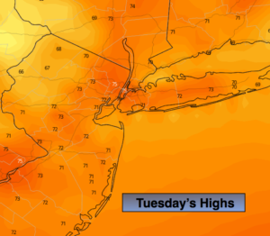
Synopsis:
Today will feature a mix of sun and clouds with comfortable readings. Our stretch of below average readings will continue. Highs will remain in the 70s as high pressure moves off the New England coast.
Clouds will dominate tonight and Wednesday. The humidity will be on the rise with a Southerly flow as a cool front approaches. Scattered showers are likely during the afternoon and evening Wednesday.
High pressure will build in from the Tennessee Valley late week. This setup will result in warmer readings and plenty of sun as we approach getaway day Friday. The Labor Day Holiday Weekend at this time looks fairly decent!
Keep it here for a no nonsense, no hype forecast.
Today:
Clouds and sun. Highs in the mid 70s. East to Southeast winds at 5-10mph.
Tonight:
Mostly cloudy. Not as cool as recent nights. Lows in the 60s throughout. Southeast to East winds at 5mph.
Wednesday:
More clouds than sun. Warmer and more humid. A few late day or evening showers and storms are possible. Highs around 80º.
Thursday:
Mostly sunny, warm and less humid. Highs in the lower to mid 80s.
Friday:
Mostly sunny, warm. Highs in the mid 80s.
Saturday:
Mostly sunny, warm. Highs in the mid 80s.