Synopsis:
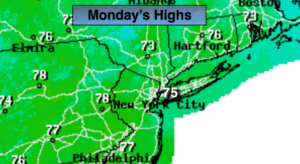
High pressure over the Northeast, which originated in Canada will continue to give the area our Fall feel. Clouds and sun are expected today. Readings will be several degrees below the average high of 81º.
It’ll be another chilly night with readings in the lower 60s in the City, near 50º well inland.
Tuesday and Wednesday will be partly sunny. Temperatures will slowly rise to near seasonal averages by midweek. A weak cool front will move through Wednesday evening and night with a few showers.
High pressure this time will build from the Tennessee Valley late week. This setup will result in warmer readings and plenty of sun as we approach getaway day Friday.
Keep it here for a no nonsense, no hype forecast.
Today:
Clouds and sun. Cool. Highs in the mid 70s. Northeast to East winds at 5-10mph.
Tonight:
Mostly clear and cool. Lows in the lower in the City, the 50s inland. Southeast to East winds at 5mph.
Tuesday:
Partly sunny. Highs in the mid to upper 70s.
Wednesday:
Partly sunny and warmer. A few late day or evening showers are possible. Highs around 80º.
Thursday:
Partly sunny, warm. Highs in the lower to mid 80s.
Friday:
Mostly sunny, warm. Highs in the mid 80s.