Synopsis:
The remnants of Barry will influence our region tonight and Thursday. A Severe Thunderstorm Watch is in effect for the entire tri-state area until 10pm. Severe thunderstorms contain one of the following criteria: Winds in excess of 58mph and or one inch hail. A Flash Flood Watch is also in effect through late tonight for the entire area. 1-2″+ of rain is possible. If you en counter a flooded roadway-TURN AROUND, DON’T DROWN.
There will be a break in the heat on Thursday with mainly cloudy skies and a wind off the cooler Atlantic. Spotty showers and storm are possible.
A heatwave will overspread the region Friday into the weekend as a Bermuda high pressure takes hold.A heatwave is defined as three consecutive days at 90º or above. Temperatures will flirt with 100º in many areas this weekend. The humidity will be high. The combination of high temperatures and humidity will result in a heat index of 100º-110º Friday through Sunday. The peak of the heatwave looks to be Saturday. I’m already perspiring thinking about it.
The heatwave should break on Monday as a cool front works through.
Stay tuned.
Keep it here for a no nonsense, no hype forecast.
Tonight:
Areas of torrential rain and thunderstorms. Warm and muggy. Lows in the lower to mid 70s throughout. Winds becoming Northeast at 5-10mph.
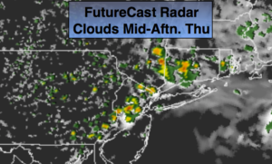
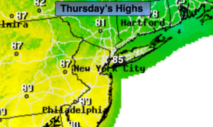
Thursday:
Mostly cloudy. Not as hot, but still humid. Spotty showers and storms. Highs in the mid 80s. East to Southeast winds at 5-10mph.
Friday:
Hazy, hot and humid. Highs in the lower to mid 90s. Heat index 100º to 105º.
Saturday:
Hazy, hot and humid. Highs 95º-100º. Heat index 100º to 110º.
Sunday:
Hazy, hot and humid. Highs 95º-100º. Heat index 100º to 110º.
Monday:
Hazy, very warm and humid. Scattered showers and storms possible. Highs in the upper 80s.