Synopsis:
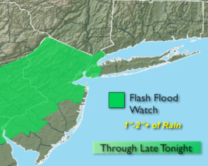
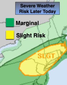
Today will be hazy, hot and humid as a Southwesterly wind prevails. Spotty showers and thunderstorms will develop later this afternoon as the remnants of Barry begin to influence our region. There is a slight risk of severe thunderstorms for the area later today and tonight. Some of the rain maybe torrential with the tropical airmass moving through. The heaviest threat of rain looks to be tonight. A Flash Flood Watch has been posted for all of New York City and most of NJ. 1-2″+ of rain is possible. If you en counter a flooded roadway-TURN AROUND, DON’T DROWN.
There will be a break in the heat on Thursday with mainly cloudy skies and a wind off the cooler Atlantic. Spotty showers and storm are possible.
A heatwave will overspread the region Friday into the weekend as a Bermuda high pressure takes hold.A heatwave is defined as three consecutive days at 90º or above. Temperatures will flirt with 100º in many areas this weekend. The humidity will be high. The combination of high temperatures and humidity will result in a heat index of 100º-110º Friday through Sunday. The peak of the heatwave looks to be Saturday. I’m already perspiring thinking about it.
Stay tuned.
Keep it here for a no nonsense, no hype forecast.
Today:
Hazy, hot and humid. Spotty PM storms. Highs in the lower 90s. Southwest winds at 8-12mph.
Tonight:
Areas of torrential rain and thunderstorms. Warm and muggy. Lows in the lower to mid 70s throughout. Winds becoming Northeast at 5-10mph.
Thursday:
Mostly cloudy. Not as hot, but still humid. Spotty storms. Highs in the lower to mid 80s.
Friday:
Hazy, hot and humid. Highs in the mid 90s. Heat index 100º to 105º.
Saturday:
Hazy, hot and humid. Highs 95º-100º. Heat index 100º to 110º.
Sunday:
Hazy, hot and humid. Highs 95º-100º. Heat index 100º to 110º.