Synopsis:
A stationary front will continue to move North and South over the next 2 days. When the front shifts to the North temperatures will pop into the 70s and when it settles South of the region readings will be very cool. Needless to say we are on a rollercoaster ride-hang on.
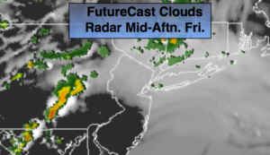
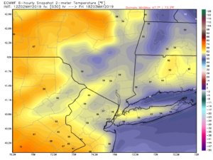
Cooler readings and the chance of spotty showers and areas of fog is the forecast for today as the stationary front slips just to the South. Much of the time it will be dry. Some sun is possible over Southern areas later in the day (1st map above FutureCast clouds/radar). Highs will be twenty to twenty five degrees cooler than Thursday (2nd map above is the expected highs for today)- it was in the lower 80s yesterday over many areas of NJ.
The better day of the weekend looks to be Saturday. The wavy front will inch back to the North. Any showers will end Saturday morning. The sun will return for many. Temperatures will again pop into the lower 70s. By Sunday a storm will develop over Western Virginia and move just South of the City. Rain is likely. Some of the rain maybe heavy. We may be able to squeak out of few hours of dry time later Sunday afternoon- don’t hold your breath.
Stay tuned.
Keep it here for a no nonsense, no hype forecast.
Today:
Mostly cloudy with spotty showers and areas of fog. Much cooler. Highs near 60º. East winds at 5-10mph.
Tonight:
Cloudy and cool with spotty drizzle and showers. Lows in the lower to mid 50s. East winds less than 5mph.
Saturday:
Any morning showers will end early, otherwise becoming partly sunny and warm. Highs in the lower 70s.
Sunday:
Rain likely. Highs in the upper 50s.
Monday:
Partly sunny. Highs in the upper 60s.
Tuesday:
Partly sunny. Warmer. Highs in the lower to mid 70s.