Synopsis:
Lows this morning approached approached 0º along the coast. Readings plummeted to -15º over parts of Northwestern NJ. Wind Chills reached -15º along the coast to -25º to -35º well inland. This is life threatening cold. Please dress in layers as that tends to deaden the air in between the layers and in turn keep you warm.
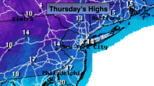
The record low today for Central Park is -1º set back in 1920. This should stand. The record minimum high temperature for the date is 16º set back in 1935. This should be broken as the forecast high is 14º.
The polar vortex will slowly lose its grip over the region by late Friday. But, until then, it will be the Arctic tundra around these parts. Skies will be mainly sunny. Readings tonight will once again fall below zero inland and will remain near 10º at the coast. The good news is the winds will have abated.
The airmass will slowly moderate as high pressure works in from the West for the weekend. Skies will be mainly sunny. By Sunday it’ll feel like a heatwave!
You know where to find a no hype, no nonsense forecast.
Stay tuned.
Today:
Mostly sunny and frigid. Highs 8º to 16º. Wind chills near 0º along the coast, below zero inland. West winds at 10-20mph.
Tonight:
Clear and bitterly cold. Lows around 10º in the City and along the coast. 0º to -10º inland. West winds diminishing to 5mph.
Friday:
Sun to Clouds. Very cold. Highs in the mid 20s.
Saturday:
Sunny and not as harsh Highs in the mid 30s.
Sunday:
Sunny and mild. Highs in the 40s.
Monday:
Partly sunny and mild. Highs near 50º.