
Synopsis:
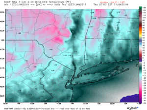
A bitter blast will once again grip the area with plummeting temperatures this evening. Readings will free-fall into the single digits during the evening with wind gusting to 40mph. The polar vortex will push it’s Arctic grip on the tri-state area. Lows will approach 0º along the coast tonight (1st map above) & Thursday morning. Inland readings will be below zero. Wind Chills will reach -15º along the coast to -25º inland (2nd map above). This is life threatening cold. Please dress in layers as that tends to deaden the air in between the layers and in turn keep you warm.
The record low Thursday for Central Park is -1º set back in 1920. This should stand. The record minimum high temperature for the date is 16º set back in 1935. This should be broken as the forecast high is 14º.
The airmass will slowly moderate as high pressure works in from the West for the weekend. Skies will be mainly sunny. By Sunday it’ll feel like a heatwave!
You know where to find a no hype, no nonsense forecast.
Stay tuned.
Tonight:
Clear and bitterly cold. Lows 0º to 5º in the City and along the coast. 0º to -6º inland. West to Northwest at 15-25mph with gusts to 40mph this evening. Wind chills -5º to -15º along the coast. -15º to -25º inland.
Thursday:
Mostly sunny and frigid. Highs 8º to 14º. Wind chills near 0º along the coast, below zero inland. West winds at 10-20mph.
Friday:
Mostly sunny and very cold. Highs in the mid 20s.
Saturday:
Sunny and not as harsh Highs in the mid 30s.
Sunday:
Sunny and mild. Highs in the 40s.
Monday:
Partly sunny and mild. Highs near 50º.