Synopsis:
A cool front will mov through today. It will come through uneventful. The front is lacking moisture so it will basically come through dry. Skies will be partly sunny. The humidity and temperature will come down some; It’ll be noticeable.
True relief will arrive on Friday. A strong High will be over Southeastern Canada. This will result in a wind off the Atlantic. Readings will be much cooler Friday and Saturday. The forecast challenge is how much moisture will work in off the ocean. At this time, clouds and some sun with scattered showers and areas of drizzle at times is expected Friday and Saturday. It will be a drastic change from the sunshine and heat of the last few days. By Sunday into Labor Day Monday the pattern will break down, hopefully resulting in more sunshine but the threat of a shower cannot be ruled out. In summary, Friday through Labor Day will not be a loss weather wise. It’ll start off damp but improve later in the weekend!
Stay tuned.
Today:
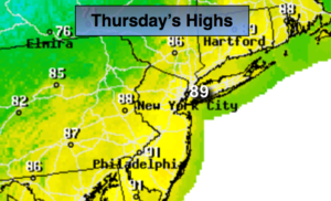
Partly sunny, very warm and not as oppressively humid. Highs in the 80s to around 90º. Winds becoming Northwest at 5-10mph.
Tonight:
Mostly cloudy and cooler. Chance of showers late. Lows near 70º in the City, the 60s inland. Winds becoming Northeast at 5-10mph.
Friday:
Mostly cloudy, much cooler and less humid. Scattered showers and areas of drizzle. Highs in the mid 70s.
Saturday:
Mostly cloudy with scattered showers and areas of drizzle. Highs in the mid to upper 70s.
Sunday:
Clouds and sun. Spotty showers are possible. Warmer and more humid. Highs in the lower to mid 80s.
Labor Day:
Hazy, warm and humid. Highs in the upper 80s.
Keep it here for a no nonsense, no hype forecast.