Synopsis:
Mother Nature may provide her own fireworks into this evening as a weak disturbance moves through. Spotty storms are possible. It will NOT be a washout and the majority of the area will remain dry. Skies will be mostly cloudy for the ooh’s and ahh’s. It’ll be humid.
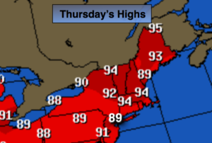
Thursday will be back up near 90º as the wind will be more off the land under hazy and humid conditions.
A significant cool front will work into the region Friday with showers and thunderstorms. Relief will finally arrive by Saturday. The weekend looks fantastic with abundant sunshine, cooler temperatures and very low humidity. It’s about time!
Stay tuned.
Tonight:
Spotty evening storms, otherwise mostly cloudy, warm and muggy. Lows in the mid 70s in urban areas, near 70º elsewhere. South winds under 5mph.
Thursday:
Hazy, hot and humid. Highs near 90º. Heat index 95º-100º. South winds at 8-12mph.
Friday:
Hazy, warm and humid. Showers and thunderstorms are likely. Highs in the mid 80s.
Saturday:
Sunny, cooler and much less humid. Highs in the lower 80s.
Sunday:
Sunny with low humidity. Highs in the mid 80s.
Monday:
Sunny and warmer with highs in the upper 80s.
Keep it here for a no nonsense, no hype forecast.