Synopsis:
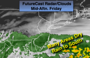
A stationary front stalled just to our South will be responsible for our unsettled weather into the weekend. A break in the rain will occur today for the NYC vicinity and to the North. It now looks like strong high pressure over Southeastern Canada will stop the rain from advancing any farther North. Over parts of Central and Southern NJ periods of rain is expected today. It will be a fine line between dry and wet (FutureCast Radar above). Temperatures will remain well below average with a stiff breeze off the cold Atlantic.
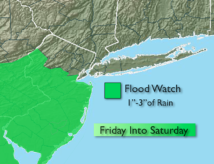
The stationary front will become a warm front and move toward the area on tonight and Saturday. The rain will work from South to North overnight. The ingredients are there for the potential of periods of heavy rain late to night and Saturday with a deep moisture plume coming up from the South. A Flood Watch has been posted for many areas of NJ (map above).
Sunday looks to be the warmer of the two days. Scattered showers are still expected but a heavy rain is not expected.
Stay tuned
Today:
Areas of morning fog otherwise, mostly cloudy from the NYC vicinity and to the North. Periods of rain South of the City. Much cooler. Highs around 60º. Becoming breezy. East to Northeast winds at 10-20mph.
Tonight:
Rain developing from South to North overnight. Lows in the 50s throughout. East to Northeast winds at 10-15mph.
Saturday:
Cloudy with periods of rain. Rain maybe heavy at times. Highs in the lower to mid 60s.
Sunday:
Cloudy with isolated showers and thunderstorms. Much warmer. Highs in the mid to upper 70s.
Monday:
Partly sunny. Highs near 80º.
Tuesday:
Mostly cloudy. Scattered showers. Highs in the lower 70s.
Keep it here for a no nonsense, no hype forecast.