Synopsis:
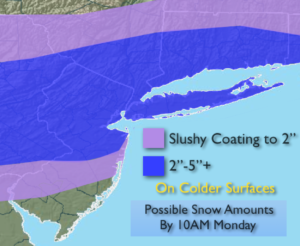
This was the most significant April snowfall for much of the tri-state area since 1982. In the vicinity of the City and nearby suburbs 3″-6″+ accumulated on colder surfaces. The Yankees home opener has been postponed. Ironically, the Yankees home opener in 1982 was postponed because of a rare April blizzard. The snow will taper off this morning from West to East as the area of low pressure moves farther out to sea. Some sun is possible later today and the rapid snowmelt will begin.
A very active early April pattern will be with us for the next week. Rapidly changing weather conditions are expected with a roller coaster ride in temperatures.
A warm front will move toward the area Tuesday with periods of rain. Once the warm front moves North on Wednesday readings should soar well into the 60s to near 70º.
Another cold front will move through Wednesday night with readings only in the 40s on Thursday.
There has been chatter about a storm for this weekend. At this time, the latest computer models have the system offshore not affecting us. I am not completely discounting the threat of the low affecting us.
Stay tuned.
Today:
Snow will taper off from West to East this morning. Highs in the mid to upper 40s. Northeast to West winds at 5-10mph.
Tonight:
Mostly cloudy. Lows in the upper 30s in the City, near freezing inland. Light and variable winds.
Tuesday:
Cloudy with periods of rain. Highs around 50º.
Wednesday:
Mostly cloudy with showers. warm. Highs in the mid 60s to around 70º over Southern areas.
Thursday:
Partly sunny and colder. Highs in the mid 40s.
Friday:
Partly sunny. More seasonal. Highs in the lower to mid 50s.
Keep it here for a no nonsense, no hype forecast.