Synopsis:
The weather will cooperate for Easter. A cool front will move through the area this morning with clouds. The sun will return soon after and it’ll be very mild.
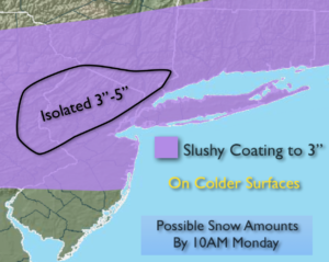
The latest computer models continue to bring a rapidly moving ripple of low pressure just to the South of the City tonight and Monday morning. At this time the potential for some snow continues to increase. The snow could be mixed with rain at the coast and in the City. Much of the snow will at night and early morning so the high April sun angle will not factor into the equation but the warm ground from the 60º readings on Easter will make it difficult for the snow to stick on the streets, especially in urban areas. Could a few slushy inches of snow on grassy or colder surfaces? Yes. First call snow amounts are above. The sun will return by midday Monday so any snow will melt by sunset.
A very active early April pattern will be with us for the next ten days. Rapidly changing weather conditions are expected with a roller coaster ride in temperatures.
Stay tuned.
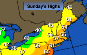
Easter Sunday:
Clouds to sun. Mild. Highs around 60º. Southwest to Northwest winds at 10-15mph.
Tonight:
Thickening clouds. Snow developing after midnight. The snow could be mixed with rain, especially over coastal and Southern sections. Lows in the mid 30s in the City, near freezing inland. Northeast winds at 8-12mph.
Monday:
A few hours of morning snow (mixed with rain in spots), otherwise becoming mostly sunny and chilly. Highs in the mid to upper 40s.
Tuesday:
Cloudy with periods of rain. Highs around 50º.
Wednesday:
Mostly cloudy with showers. warm. Highs in the mid 60s to around 70º over Southern areas.
Thursday:
Partly sunny and colder. Highs in the mid 40s.
Keep it here for a no nonsense, no hype forecast.