Synopsis:
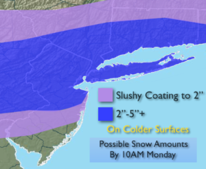
A rapidly moving ripple of low pressure will move from Northern Virginia tonight to well off the NJ coast by midday Monday. This will cause an April snowfall for most of the tri-state area. Snow will develop after midnight tonight and continue into the morning hours on Monday. The snow could be mixed with rain at the coast and in the City. Much of the snow will at night and early morning so the high April sun angle will not factor into the equation but the warm ground from the 60º readings on Easter will make it difficult for the snow to stick on the streets, especially in urban areas. An accumulation is expected on grassy and colder surfaces (map above). The streets will have a much lower total. The snow will end from West to East during the mid to late morning. The sun will return by afternoon.
A very active early April pattern will be with us for the next ten days. Rapidly changing weather conditions are expected with a roller coaster ride in temperatures.
Stay tuned.
Tonight:
Thickening clouds. Snow developing after midnight. The snow could be mixed with rain, especially over coastal and Southern sections. Lows in the mid 30s in the City, near freezing inland. Northeast winds at 8-12mph.
Monday:
A few hours of morning snow (mixed with rain in spots), otherwise becoming mostly sunny and chilly. Highs in the mid to upper 40s. Northeast to West winds at 5-10mph.
Tuesday:
Cloudy with periods of rain. Highs around 50º.
Wednesday:
Mostly cloudy with showers. warm. Highs in the mid 60s to around 70º over Southern areas.
Thursday:
Partly sunny and colder. Highs in the mid 40s.
Friday:
Partly sunny. More seasonal. Highs in the lower to mid 50s.
Keep it here for a no nonsense, no hype forecast.