Synopsis:
The Holiday Weekend is looking good with a decent amount of sunshine and pleasant readings as high pressure moves in. A cool front will move through Easter Sunday morning uneventful.
The latest computer models bring a rapidly moving ripple of low pressure just to the South of the City Sunday Night and Monday morning. At this time there is a threat of a few hours of snow. The computer models continue to show this feature, so my confidence has increased some. Also, if the snow materializes (rain could be mixed with the snow at the coast) it will fall mainly at night so the high April sun angle will not factor into the equation. Could a few slushy inches of snow on grassy or colder surfaces? Yes. The sun will return by midday Monday so any snow will melt by sunset.
A very active early April pattern will be with us for the next ten days. Rapidly changing weather conditions are expected.
Stay tuned.
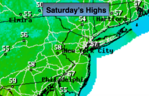
Today:
Mostly sunny. Pleasant. Highs in the upper 50s. North to South winds at 5-10mph.
Tonight:
Clear early with increasing clouds late. Lows around 40º in the City, the 30s inland. South to Southwest winds at 5-10mph.
Easter Sunday:
Partly sunny. Highs in the mid 50s.
Monday:
Low threat of a few hours of morning snow (mixed with rain in spots), otherwise mostly sunny and chilly. Highs in the mid to upper 40s.
Tuesday:
Cloudy with periods of rain. Highs around 50º.
Wednesday:
Mostly cloudy with showers. Mild. Highs in the upper 50s.
Keep it here for a no nonsense, no hype forecast.