Synopsis:
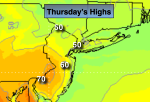
A warm front will approach the area today. This will result in mainly cloudy skies with on and off showers, in fact much of the time will be dry. This front will struggle to move North of the immediate NYC vicinity this afternoon. Low clouds and areas of fog is possible the Northern half of the area to the North of the front with the wind off the cold Atlantic. To the South of the front the sun should shine over parts of central and Southern NJ. Temperatures will pop with readings possibly getting well into the 60s in this area (map above).
The warm front will move North of the area tonight. Temperatures will actually rise into and through the 50s. A storm attached to the front in Central PA will move rapidly into Southeastern Canada by Friday afternoon. This system looks weak and shouldn’t add to much more than a few showers Friday. It will be warm with high reaching the 60s. It should be dry for the beginning of Passover- sundown Friday.
The Holiday Weekend is looking good with a decent amount of sunshine and seasonal readings. A cool front will move through Easter Sunday uneventful.
Today:
Mostly cloudy with a spot shower. Areas of Fog. Highs only in the 40s North and East of the City, to the 60s over Central and Southern NJ. East wind at 5-10mph.
Tonight:
Mostly cloudy with spotty showers and patchy fog. Readings will remain in the 50s throughout the tri-state area. East winds will become South at 5mph.
Friday:
Clouds and sun. Warm. Slight chance of a shower. Highs in the mid 60s. Passover begins at sundown at 7:19PM.
Saturday:
Partly sunny and seasonal. Highs in the mid 50s.
Easter Sunday:
Partly sunny. Highs in the lower to mid 50s.
Monday:
Partly sunny and chilly. Highs mid to upper 40s.
Keep it here for a no nonsense, no hype forecast.