Synopsis:
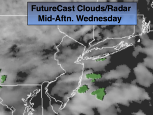
A weak front and disturbance in the upper levels over the Appalachians will result in mainly cloudy skies for mid to late week. Showers chances will be with us this evening through Friday. It will not be a washout, in fact much of the time will be dry. Temperatures will go above average by tomorrow with a Southerly flow as the high pressure forms off the Southeast coast. It will finally feel like Spring.
A storm will develop over the Ohio Valley Thursday night and rapidly move into Southeastern Canada by Friday afternoon. This system looks weak and shouldn’t add to much more than a few showers. It should be dry for the beginning of Passover- sundown Friday.
The Holiday Weekend is looking good with a decent amount of sunshine and pleasant readings.
Today:
Mostly cloudy with a spot shower. Highs around 50º. South wind at 5mph.
Tonight:
Cloudy with a few sprinkles. Lows in the mid 40s in the City, the upper 30s to around 40º inland. South to East winds at 5mph.
Thursday:
Mostly cloudy with a spot shower. Mild. Highs in the mid to upper 50s.
Friday:
Clouds and sun. Mild. Slight chance of a shower. Highs in the lower to mid 60s. Passover begins at sundown.
Saturday:
Partly sunny and seasonal. Highs in the mid 50s.
Easter Sunday:
Partly sunny. Highs in the lower to mid 50s.
Keep it here for a no nonsense, no hype forecast.