Synopsis:
An upper level low swinging in from the North and West may cause spotty rain or snow showers this afternoon. This will not be a big deal, otherwise a mix of sun and clouds are expected with below average readings. The average high for today is 52º.
High pressure will nose in from Canada and keep the chill around despite the sunshine into the weekend. This high should suppress a weak storm moving out of the Midwest to the South on Sunday.
Looking down the pike more seasonal Spring temperatures should be on the way by midweek.
Stay tuned.
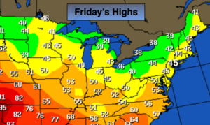
Today:
Sun and clouds. A spot rain or snow shower. Highs in the mid 40s. Northwest winds at 8-12mph.
Tonight:
Partly cloudy. Lows around freezing in the City, the upper 20s inland. There will be a refreeze of the slush, please use caution. Northwest 5-10mph.
Saturday:
Partly sunny. Highs in the mid 40s.
Sunday:
Partly sunny. Highs in the lower to mid 40s.
Monday:
Sunny. Highs in the mid 40s.
Tuesday:
Partly sunny, milder. Highs in the lower 50s.
Keep it here for a no nonsense, no hype forecast.