Synopsis:
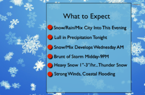
A storm will off the Mid-Atlantic coast tonight. A period of snow, sleet and or rain is possible through this evening mainly from the NYC vicinity and to the South. A slushy coating is possible in colder areas.
Additional energy in the jet stream diving South into the Carolina’s later tonight and Wednesday. A storm will form East of the Virginia coast by morning . The latest computer models are in unison. This storm will rapidly intensify and move to the Northeast just off the coast. Confidence continues to increase that a Spring Nor’easter will occur. Wet snow and or rain will develop during the morning hours. The morning commute will not be the worse of the two commutes. The evening commute will be hazardous and it will be dangerous to be outdoors. The brunt of the storm will be from midday through 9PM this is when bombogenesis will occur. During this time the snow could come down at 1″-3″/hr at times. Whiteout conditions are possible with thunder snow. Unfortunately power outages and tree damage is once again possible.
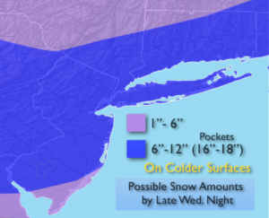
A Winter Storm Warning has been posted for the entire area for the likelihood of 6″-12″ or more of snow. There will be a sharp cutoff to the heavy snow amounts to the North and Northwest (see map above).
The sun angle will play into the equation of how much snow will stick during the daylight hours (it has to snow at a very good rate for snow to accumulate during the day).
It will be very windy with gusts up to 50mph at the coast. Coastal flooding is possible during the times of high tide Wednesday morning and evening.
Please check in frequently to this site. A high impact event is likely Wednesday. Please keep it here for a no hype, no nonsense forecast.
Stay tuned.
Tonight:
Cloudy with spotty a spotty light mix at times mainly from the City and to the South this evening. Remaining cloudy after midnight. Lows freezing in the City, the 20s inland. Increasing North to Northeast winds at 15-30mph with higher gusts late.
Wednesday:
Wet snow, mix and rain changing to mainly wet snow and becoming heavy at times. Windy conditions. Whiteout conditions and thunder snow are possible during the afternoon. Highs in the mid 30s. North to Northeast winds at 15-30mph with gusts to 50mph at the coast.
Thursday:
Clouds giving way to some sun. Windy. Highs in the lower 40s.
Friday:
Partly sunny, Breezy. Highs in the mid 40s.
Saturday:
Partly sunny. Highs in the mid 40s.
Sunday:
Partly sunny. Highs in the mid 40s.
Keep it here for a no nonsense, no hype forecast.