Synopsis:
The storm that gave the area anywhere between a slushy coating and over two feet of snow will pull into Eastern Canada through the end of the week. Readings will be a few degrees below average with a mix of sun and clouds. Temperatures will be just below average and snowmelt will continue..
By the weekend high pressure will nose in from Canada with more sunshine and near normal temperatures.
A storm will be on the map on Sunday over the Southern states. Will that storm move out the sea to the South or will it take a turn up the coast. There is a low threat of the storm affecting right now. Many days to watch how this unfolds.
Stay tuned.
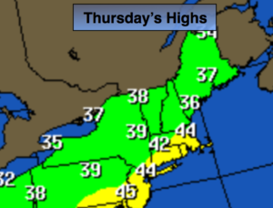
Today:
Clouds and some sun. Highs in the lower to mid 40s. West to Northwest winds at 10-15mph.
Tonight:
Mostly cloudy. Lows near freezing in the City, the upper 20s inland. West winds at 5mph.
Friday:
Partly sunny. Breezy. Highs in the lower to mid 40s.
Saturday:
Partly sunny. Breezy. Highs in the lower to mid 40s.
Sunday:
Partly sunny. Highs in the lower to mid 40s.
Monday:
Mostly cloudy. Low threat for some snow. Highs in the lower 40s.
Keep it here for a no nonsense, no hype forecast.