Synopsis:
A high impact storm will affect the region today and tonight. A storm is developing along the Mid-Atlantic coast. This storm will intensify at a good clip and move up the coast today. The latest computer models continue with a coastal hugger. All the models are cranking out heavy precipitation totals. The potential continues to increase for heavy snow for most of the area. Even though the storm will be so close to the coast, the upper level low will deepen rapidly and supply the cold air. Along the coast, Central and Southern NJ and over Eastern Long Island some rain or a mix will occur. This should keep accumulations much lower.
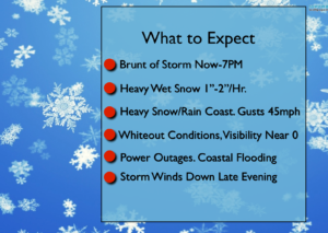
This will not as potent as the last Nor’easter with wind and coastal flooding but snow may fall in a larger area. Wind gusts to 45mph are likely later today especially along the coast. Heavy wet snow accumulations on trees and power lines may cause scattered power outages. Minor coastal flooding is possible at the times of high tide.
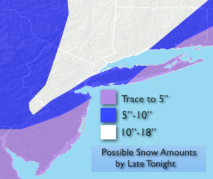
The possible snow amounts are above and they are significant.
The brunt of the storm will be during the afternoon and early evening. Snow may fall at 1″ to 2″/hr. causing near whiteout conditions. It will be dangerous to be outdoors. The snow will taper off from West to East during the evening.
Tranquil conditions are expected for the end of the workweek.
Stay tuned.
Today:
Snow. Becoming heavy at times. Snow/mix or rain at the coast. Windy. Highs in the mid 30s. Northeast 15-30mph with gusts to 45mph.
Tonight:
Snow (rain out East) ending from West to East during the evening. Lows near freezing in the City, the 20s inland. Northwest wind diminishing to 10-20mph.
Thursday:
Partly sunny. Highs in the lower to mid 40s.
Friday:
Partly sunny. Highs in the lower to mid 40s.
Saturday:
Partly sunny. Highs in the lower to mid 40s.
Sunday:
Partly sunny. Highs in the lower to mid 40s.
Keep it here for a no nonsense, no hype forecast.