Synopsis:
High pressure will continue to nose in from Canada resulting in sun and clouds and seasonal readings tomorrow.
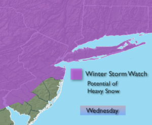
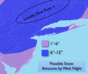
Another storm threat is on the way-Wednesday will be the day of concern. A weak low over the upper Ohio Valley will dissipate as a secondary storm develops over coastal North Carolina Tuesday night. This storm will intensify at a good clip and move up the coast on Wednesday. The latest computer models have come in unison on a general solution- a coastal hugger. All the models are cranking out heavy precipitation totals. The potential is there for heavy snow. Even though the storm will be so close to the coast, the upper level low will deepen rapidly and supply the cold air. Along the coast and over Eastern Long Island some rain or a mix will occur. Here too the cold air will win out and snow will eventually prevail. A Winter Storm Watch is up for most of the tri-state area for Wednesday.
This will not as potent as the last Nor’easter with wind and coastal flooding but snow may fall in a larger area. The possible snow amounts are above and they are significant. This amounts will change as we get closer to the event and are not etched in stone.
The snow will start before the AM commute on Wednesday and end Wednesday night.
Tranquil conditions are expected for the end of the workweek.
March has roared in and the latest extended computer guidance suggests another storm threat is on the map for Sunday and next Monday.
Stay tuned.
Tonight:
Partly cloudy and breezy. Lows around freezing in the City, the mid to upper 20s inland. North wind diminishing to 5-10mph.
Tuesday:
Partly sunny. Highs in the mid 40s. Northeast to Southeast 5-10mph.
Wednesday:
Snow. Heavy at times. Snow or a mix of snow and rain at the coast changing to snow. Highs in the mid 30s.
Thursday:
Partly sunny. Highs in the lower to mid 40s.
Friday:
Partly sunny. Highs in the lower to mid 40s.
Saturday:
Partly sunny. Highs in the lower to mid 40s.
Keep it here for a no nonsense, no hype forecast.