Synopsis:
High pressure will continue to nose in from Canada resulting in sun and clouds and seasonal readings both Monday and Tuesday.
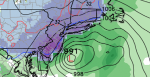
Another storm threat is on the way-Wednesday will be the day of concern. A weak low over the upper Ohio Valley will dissipate as a secondary storm develops over coastal North Carolina Tuesday night. This storm will intensify at a good clip and move up the coast on Wednesday. Most of the computer models are in good agreement with this track with some minor differences. With such a unisen in the output there a moderate potential of accumulating snow for a large part of the tri-state area. The second map above is the GFS model which shows the snow (purple) and some rain at the coast. Rain or a mix is possible at or close to the coast but these details will be ironed out as we get closer to the event. Again, this is for Wednesday. This will not as potent as the last Nor’easter with wind and coastal flooding but snow may fall in a larger area. Several inches of snow is possible if the latest track comes to fruition.
Tranquil conditions are expected for the end of the workweek.
March has roared in and the latest extended computer guidance suggests another storm threat is on the map for Sunday and next Monday.
Stay tuned.
Tonight:
Partly cloudy and breezy. Lows around freezing in the City, the mid to upper 20s inland. North to Northwest winds at 10-20mph.
Monday:
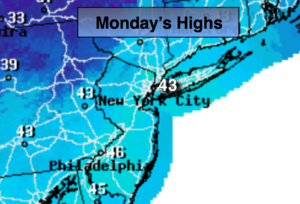
Partly sunny. Highs in the mid 40s. North winds at 10-20mph.
Tuesday:
Partly sunny. Highs in the mid 40s.
Wednesday:
Chance of snow. Snow or a mix of snow and rain at the coast. Highs in the mid 30s.
Thursday:
Partly sunny. Highs in the lower to mid 40s.
Friday:
Partly sunny. Highs in the lower to mid 40s.
Keep it here for a no nonsense, no hype forecast.