Synopsis:
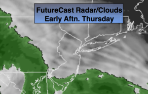
March will come in like a lion. A storm will develop over the midwest today and throw a warm front into the area. Rain will develop during the afternoon hours and continue through the night. The storm will transfer its energy to a rapidly developing secondary storm just off the coast of NJ. The exact location of this second storm and how it moves will determine our weather conditons for Friday. The latest computer models have the storm bombing off or over Eastern Long Island and doing a loop de loop just offshore on Friday. Questions that need to be answered. 1. How much precipitation will fall on the backside of the storm? 2. What areas will see the wet snow? 3. How serious will the coastal flooding will occur, and how strong will the winds become ?
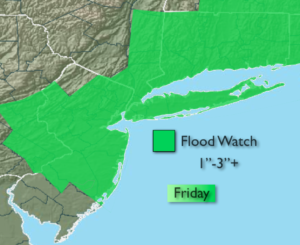
A Flood Watch has been posted for Friday for potential of 1-3″ of rain. The ground is saturated and heavy rain will quickly lead to flooding of streets, streams and creeks.
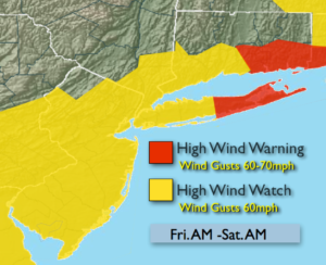
High Wind Watches and Warnings have been posted for the potential of wind gusts to 60mph.
Coastal tidal flooding is possible at the time of high tide Friday and Saturday. Tides of 1-3′ above normal is expected.
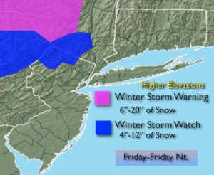
Winter Storm Watches and Warnings have been posted for heavy wet snow over the higher elevations well inland.
The thinking is rain with some wet snow mixed in North and West will occur. Accumulations maybe hard to come by with much of the precipitation falling during the day, but if the snow falls hard enough an accumulation can occur inland. The March sun angle is higher than it was in the dead of Winter and it’ll be just marginally cold enough for some wet snow. But, there is a low potential for the rain to completely go over to wet snow inland and possibly the nearby burbs of NYC. If this occurs, an accumulation is likely. These details need to be ironed as new computer guidance comes in. Please check in frequently as this could become a rapidly deteriorating situation on Friday.
The storm finally pulls off our coastline to the Southeast Friday night, ending the precipitation but the winds will be strong.
Saturday will be very windy with clouds and sun. Sunday the winds will ease some under sunny skies. Both days will feature highs in the 40s.
Stay tuned
Today:
Any early morning sun will give way to cloudy skies. Rain will develop during the mid to late afternoon. Highs in the mid 50s. East to Northeast winds at 5-10mph.
Tonight:
Rain. Heavy at times late. Lows around 40º in the City, the upper 30s inland. East winds at 5mph increasing to 10-15mph late.
Friday:
A chance of rain. A mix of rain and wet snow is possible inland. There is a low potential for the rain to completely go over to wet snow inland. An accumulation is possible over the higher elevations. Becoming very windy. Highs in the 40s, 30s inland.
Saturday:
Clouds and some sun. Windy. Highs in the mid 40s.
Sunday:
Mostly sunny. The winds will ease some. Highs in the mid 40s.
Monday:
Mostly sunny. Highs in the mid to upper 40s.
Keep it here for a no nonsense, no hype forecast.